|
It's a short walk from the canvas cabins at Costanoa down the road to the turnoff
for the Whitehouse Creek Trail. We followed the trail down and turned left to
cross the bridge over the now mostly dried-up creek. We wouldn't see anyone else
on the trail for a couple hours.
Costanoa sits near a large stand of eucalyptus trees. However, the Whitehouse Creek Trail doesn't
have much of anything in terms of vegetation. There's mostly scrub brush close at hand. There's
lots of these plants which what look like big feather-dusters growing out of them, about 6-10 feet high.
I've seen them many times before (especially when growing up, walking in Hillside Park in El Cerrito),
but I don't know what they're called.
It was November, and it hadn't rained in months, so the ground was bone dry. We followed the trail
as it climbed very gently, winding its way on the east side above Costanoa. The higher it goes,
the better the views of the Pacific Ocean. However, the best views wouldn't come until much later.
We turned right at the fork and then immediately left onto the Whitehouse Creek Road. This dirt
road does have some relatively light traffic, so be careful. In fact, this was one of least
enjoyable stretches
of hiking I've encountered in my time, since we ran into about 10 cars along the way, some of
them being driven a little too fast for the conditions (and mostly by juveniles, it seemed).
We followed the road for about a mile before Jean noticed a small little green worm floating in
space, crawling up a thin spider line. I stopped to take some pictures as more cars passed us by.
Eventually we continued on our way, trying not to get run over. The trail eventually passes
next to Whitehouse Creek itself, and soon after that we reached the trailhead. There's a sign
on the road here which says no trespassing, and a large dirt turnout on the left side. It looks
like a decent place to park, and there are no "no parking" signs there, but we didn't see any cars
parked there.
The trail heads up into the forest on the redwood right. We stopped for a few minutes to
eat a snack, then headed up the steep trail. It's only a little over a mile from here to Upper
Vista Point, but it climbs nearly 900 feet. The trail designers didn't believe in making
easy switchbacks -- the trail is quite steep in places.
The trail climbs through the redwood forest, first passing Lower Vista Point. Along the way we
saw a couple hikers coming in the opposite direction -- the first hikers we'd seen all day so far.
We decided to pass on Lower Vista Point and continued straight through to Upper Vista Point. Here,
a sign tells you the overlook is to your right, with the main trail heading left and up to Chalk
Mountain. We chose the right fork, which wanders along the ridge for two or three minutes before
stopping at a grand view and a nice informative display. The view looking west goes from Pigeon Point on
the right (north) to Ano Nuevo on the left (south). The display included the interesting fact that
the trail we'd just been on is actually quite new -- it was constructed in 1998.
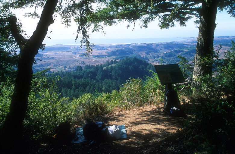
View from Upper Vista Point
This is a perfect spot to eat lunch, with ample shade but fantastic views. I took some pictures
before settling down to eat. As I was
sitting there, I noticed a sound in the distance. It took me a little while to realize that it
was the sound of elephant seals way off in Ano Nuevo. I was amazed that I could hear them
considering how far away they were, but I guess there was nothing between them and me but empty
space.
A group of a half dozen hikers came by and shared the view with us for a few minutes. They decided
to double back and head on up to Chalk Mountain. We enjoyed the view for another 20 minutes
before we did the same. The trail continues for another 0.3 miles before dropping onto Chalks Road,
a wide dirt road on which you probably won't find any car traffic. We turned left and headed up
the road for another half mile until we reached Chalk Mountain Lookout, elevation 1607 feet.
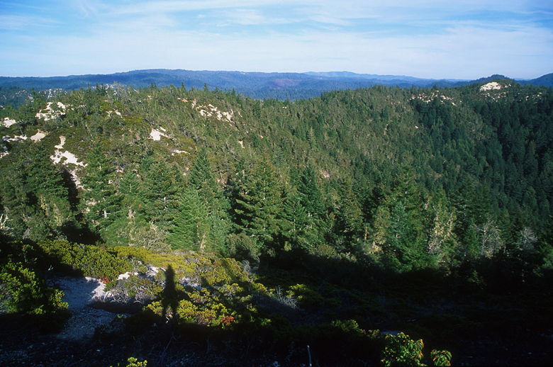
View from Chalk Mountain looking east
Chalk Mountain affords nearly 360 degree views, with rolling forested hills to the east and the
Pacific Ocean to the west. One downside is that the geography does not allow for a view of the
Pigeon Point light house from here (which Upper Vista Point does). Also, the top is marred by
a giant communications tower, solar panels, and two small steel shacks.
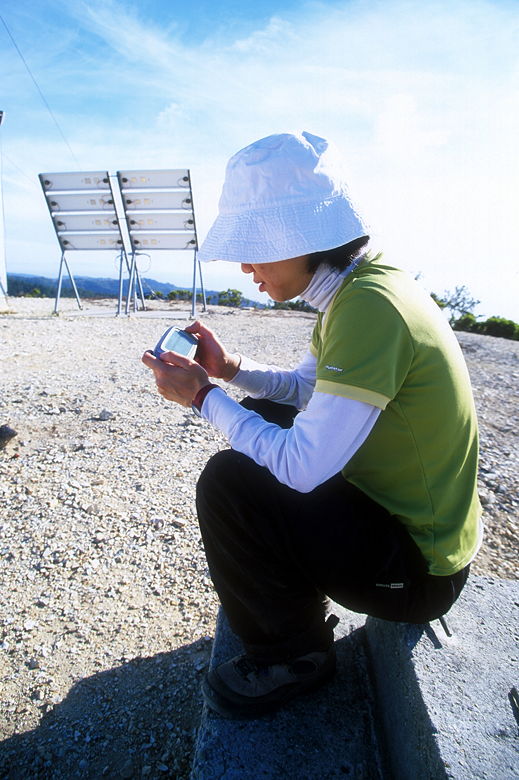
Jean using the Sidekick on the summit to read her e-mail
This is the first hike on which I brought my T-Mobile Sidekick. I hadn't been able to get a signal
earlier in the hike, but now that we were at the top, I was able to get a good signal and download
all my e-mail for the past day, storing it for later reading. I sent an instant message, too, for
good measure. I wonder if this will change the way I do my trip reports. Certainly, it may allow
me to jot down details I may otherwise forget. Then again, I'm out of cell phone coverage for
many of the hikes I do, so don't expect live field reports. :)
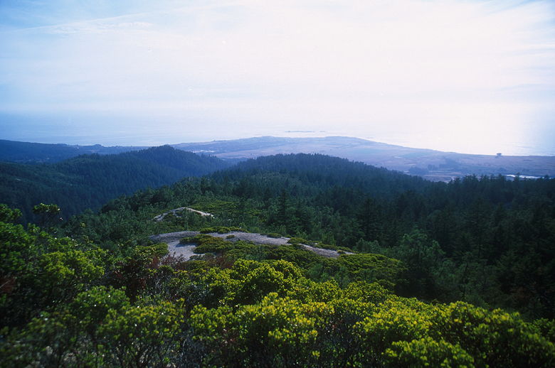
View from Chalk Mountain looking west
The other group of hikers headed back down, leaving us to enjoy the view by ourselves. After
enjoying the view and playing with the Sidekick, we turned around and headed back down. It's
pretty steep so I was glad we had our trekking poles with us. We stopped briefly to check out
the view from Lower Vista Point, but it was disappointing in comparison to Upper Vista Point and
Chalk Mountain.
I was a bit surprised to run into a couple of hikers coming in the opposite direction at this late
hour (around 3:30pm). Maybe they wanted to watch the sun set from up there. In any case, we said
hello and then rejoined the Whitehouse Creek Road, trying to spend as little time as possible on the
road. Instead of waiting until we reached the trail we'd taken, we turned right onto a trail which
wound its way down and eventually joined the one we'd taken. We then followed the trail
uneventfully back toward the bridge. Along the way we were able to glimpse the last of a
wedding ceremony on the lawns of Costanoa.
| 

