|
The first thing you should know about this hike is that it's in Torrey Pines State Natural Reserve,
not to be confused with Torrey Pines State Beach. The second thing you should know is that parking
can be a challenge.
When we arrived at around 11:30am, the parking lot was completely full, and cars were
circling, waiting for spots. if this lot is full, there aren't a lot of options -- there
is a very small amount of roadside parking further down the hill, near the Guy Fleming Trailhead.
Even if you parked there, you'd have to walk back up the hill to the trailhead. The other option
is the main parking lot at the entrance to the park. There's plenty of space there, but then
you'd have to hike all the way up the road. People do it, but it will add a significant amount of
mileage and climbing to the hike.
Thankfully, for us, the parking lot started to clear a bit before noon. Apparently people were
leaving for lunch. By noon, there were several empty spaces, and by the time we were done with
our hike, there were about a dozen empty spaces. Note, also, that there are actually two parking
lots, on either side of the road. Both are relatively small, however. If possible, park at the
one on the right, since that's next to the trailhead.
After we finally secured a parking space, we looked out to see a bench with an illustrated sign
telling us that we couldn't eat on the bench. I looked at the park map and it said that food was
not allowed on the trail -- only at the beach. I found this curious, but we obliged and ate
lunch in our car instead, before we headed out onto the trail.
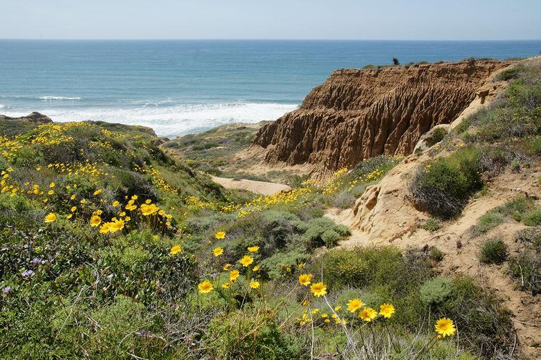
After lunch, we headed out on the trail. We immediately visited a viewpoint on the right side
of the trail. Here, we obtained our first glimpse of the ocean and the bluffs we were headed
to. Then we returned to the main trail. It winds its way steadily downhill, providing better
and better views as it descends. Along the way are wildflowers, cactus, and the occasional
Torrey pine.
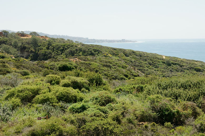
La Jolla as seen from Torrey Pines
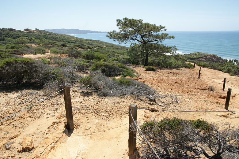
The trail down to Razor Point
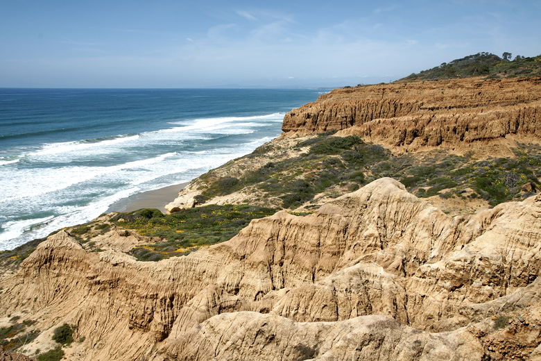
At the first trail intersection, we took the right fork to continue toward Razor Point. Soon
we were at an overlook, but that's not Razor Point. After taking in some views, we continued
along the trail, turning right again at the next intersection. When in doubt, just keep to the
right and eventually you'll reach Razor Point. The trail dead-ends at Razor Point, with a wooden
fence surrounding the lookout. Here you're on top of a coastal bluff and can look up and down the
coast.
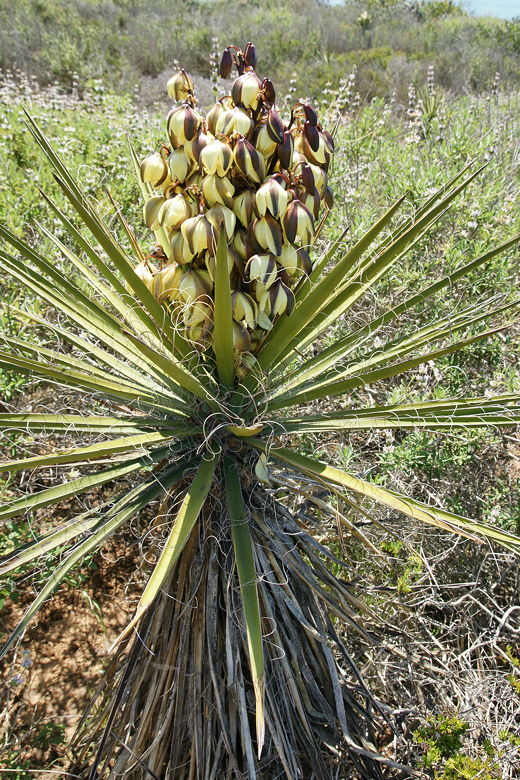
Yucca bloom
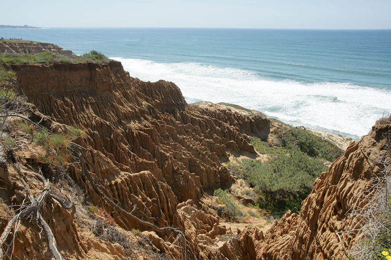
Ocean crashing toward interesting formations near Razor Point
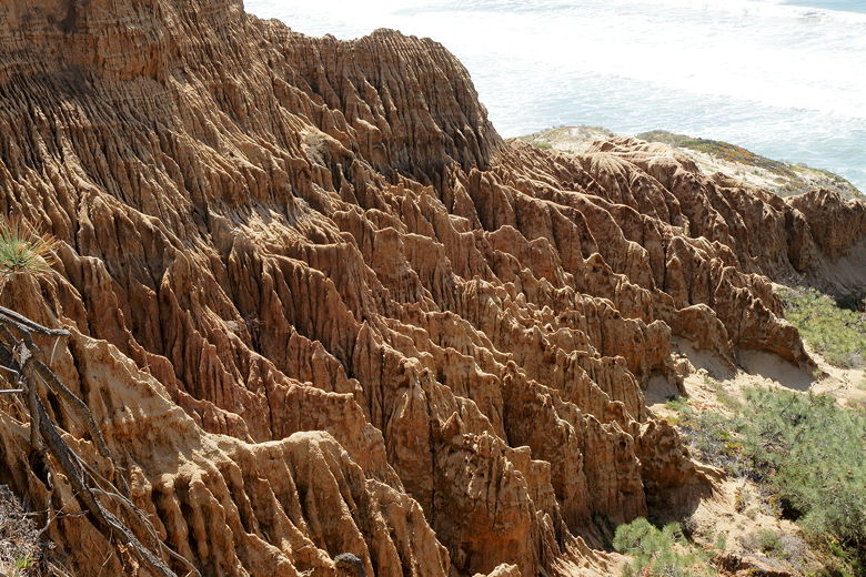
Formations near Razor Point
A park volunteer happened by while we were there, and I asked him about the food prohibition.
He said that it was simply because people are careless, leaving food and garbage on the trail,
and the prohibition was to prevent it. I find it a bit strange that this one particular park
has this prohibition (I have never seen any other park prohibit eating food while on the trail).
Maybe it's because it's such a popular park and the trails are relatively short.
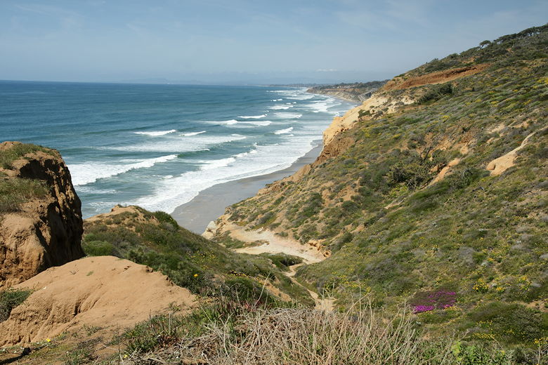
View looking north up the coast from Razor Point
View looking north up the coast from Razor Point
Our son was getting hungry, so we were anxious to get to the beach so that he could eat.
We backtracked to the last trail intersection, then turned right to head toward Yucca Point and
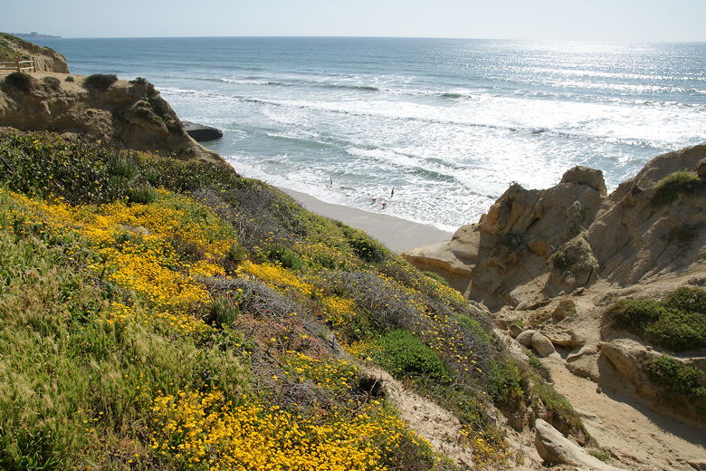
Flat Rock. Here we saw lots of yellow wildflowers along the trail.
At the next intersection, we turned right and found ourselves at Yucca Point. From
here we could look up the coast to Razor Point where we'd just been. We could also see Flat Rock
and the beach below. Further south, we could see lots of paragliders near the coast.
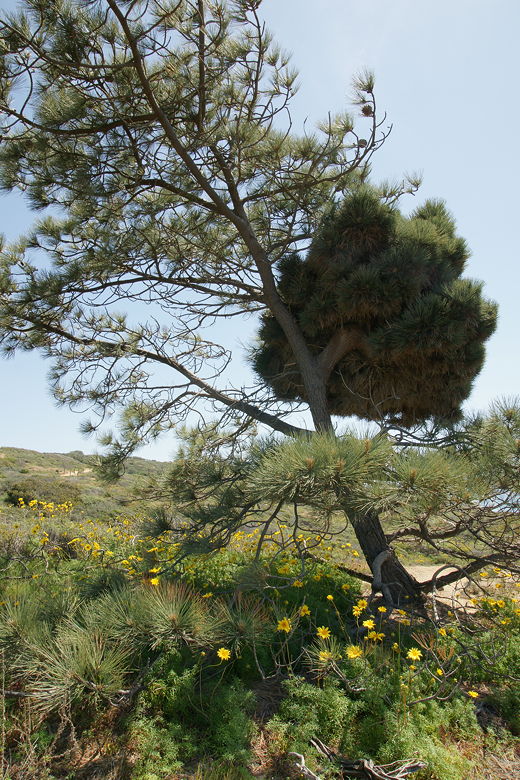
Strange-looking pine tree
Yellow flowers dotting the hillsides
Looking back at Razor Point
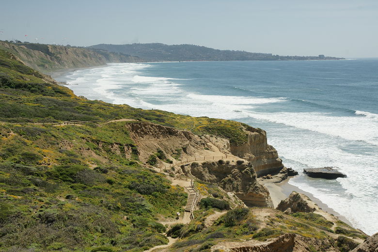
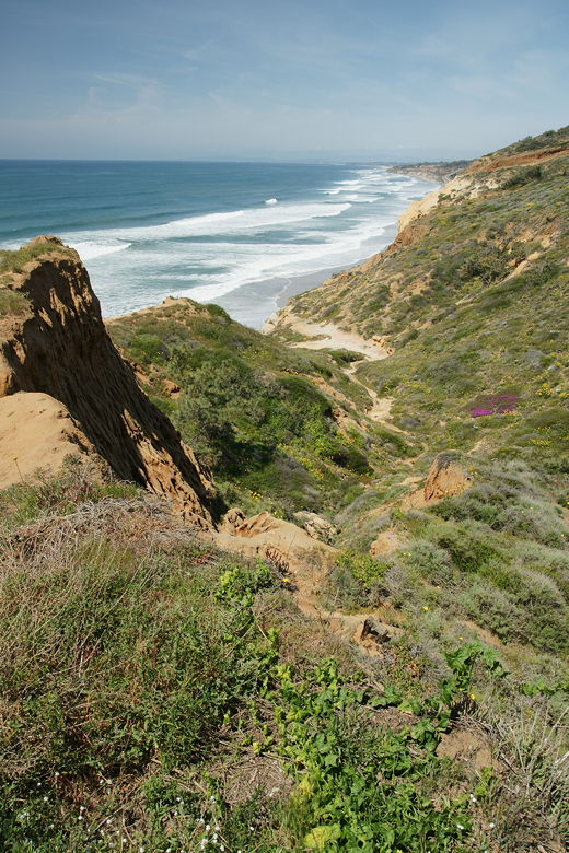
View of Flat Rock from Yucca Point
We backtracked to the main trail, then turned right and then right again to head to the beach.
The trail descends some steps along the way as it descends to the beach. At the bottom is a
sign warning that the cliff faces have been known to crumble and fall to the beach, and that
people should avoid the base of the cliffs.
The beach
From there, we turned right to head down to the beach itself. The last section of the trail is
a metal staircase that leads to the sand. We now looked for a good spot to rest and have a snack.
The beach is relatively narrow, or at least it is at high tide (which it was, although we didn't know it).
We walked north along the beach before we found what seemed like a suitable spot, trying not to get
too close to the base of the cliffs.
We put our packs down and started to take off our shoes, when all hell broke loose.
Suddenly, I felt water running into my shoes. I looked down and saw that the water was rising
about 18 inches up my legs soaking my feet. It took me a second to register what was happening.
By the time I looked up, a man standing in the water was running around, throwing my son's shoes
back toward us (my son had already taken them off and they'd been swept away). The man was
also carrying my backpack, which had also been carried out toward the ocean.
My other (younger) son was wailing, having been knocked off his feet and getting a faceful of wet
sand. For the next several minutes he was fearful anytime a wave approached the beach, even though
nothing else ever threatened. Meantime, we tried to pick up the pieces, drying things off and figuring
out where we'd gone wrong.
When we had first come to the beach, I'd seen the pattern of waves and tried to stay appreciably away
from them. I'm usually pretty conservative in this regard; I was already higher up the beach when one of the waves
had chased Jean up the beach. Apparently we weren't conservative enough. In retrospect, we should
have realized that the sand we were walking on was wet, meaning that waves had in the recent past come
this far.
As far as I can tell, this one rogue wave had come higher up than normal, surprising us. We were
lucky that the good samaritan acted as fast as he had, saving my son's shoes and my backpack with
three camera lenses in it. He wasn't able to save my son's socks (probably somewhere in the
Pacific now), but that's a small loss. The funny thing was that his young daughter was completely
unfazed, playing and laughing in the rough water. He also mentioned to us that years ago, he used
to land small planes on this beach. We couldn't imagine that now, but I guess at low tide it's
wide enough.
Once again I was grateful to a stranger, and once again I felt a bit of shame at making a
mistake. I've made my share of mistakes on the trail, and I don't mind owning up to them.
But I do realize that any decision I make may get picked apart by readers of this site, so
I suppose I feel the need to be more responsible than I otherwise would. My mistake this time
was probably not looking at a tide chart, and not checking the weather forecast. If I had, I might
have known that there was a high surf advisory for the area -- something I probably wouldn't have
considered otherwise, since it was a clear sunny day.
As it was, it could have been worse. We and our stuff was wet, but we were otherwise fine.
We laid our stuff out to dry,
and in order to avoid any more rogue waves, we went closer to the dangerous cliff bases that we
knew we shouldn't get too close to. Of course a couple people took it upon themselves to tell
us we were being idiots for being so close to the cliffs, which only served to infuriate me.
Meanwhile, people walked right where we had walked before, with no incident. Not a single wave
came even close to approaching what had hit us. After we had recovered, we packed our things and
returned to the metal staircase, and headed back up the Beach Trail that we had descended.
We kept to the right the rest of the way, following the trail as it climbed back up to the
parking lot. The next time we visit the beach, we'll definitely be more cautious, and I hope
you will, too.
| 

