|
Saturday morning, we got up and had breakfast in our motel room -- donuts, oatmeal,
and orange juice. Our last meal before our trip. I'd hoped to leave by 9am and
start the hike around 10am. We ended up leaving at 9:30am, arriving at Crabtree
Camp at 10:30am, but with last-minute adjustments, we ended up not hitting the
trail until almost 11:30am.
The drive along Crabtree Road is mostly paved, though there are some dirt sections.
The parking lot is huge, and was mostly full on this Saturday in August. Don't
let the size of the parking lot scare you away, though. My guess is that most
people who park there never get past Camp Lake.
The trail starts climbing immediately. It's a dusty trail through a conifer
forest. It had been 100 degrees in Sonora the day before, but it was in the
low 80's here at higher elevation. Besides the dust, you'll also soon notice
another trait of the trail -- horse shit. You'll undoubtedly meet horsepackers
along the trail, as we did. I'm impressed that the horses can navigate some
of the rockier parts of the trail. On the other hand "impressed" would not be
the first word to come to mind when looking at their effects on the trail.
After an hour we stopped for lunch amongst the trees. Bees buzzed around us
as we ate. After lunch we continued climbing. The trail levels out for some
stretches. At one point we passed through a forest of aspen trees, which is
something I haven't seen much of while hiking in the Sierras.

Looking up at some aspens
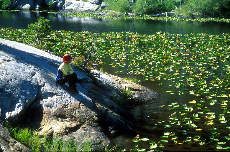
Camp Lake is just under 2.8 miles from the trailhead. There were several people
enjoying the lake, but none fishing or swimming. We stopped and rested awhile
before continuing on the trail. Near the end of the lake, we reached the top
of some rock steps. An unmarked path veered right. I was pretty sure we
wanted to take the steps, but I wanted to make sure that the steps weren't an
unsigned path toward Bear Lake. There happened to be a large group of hikers
(about 20 or so) coming up the steps toward us, so I waited and then asked one
of them if they'd come from Bear Lake. One of them answered no, but there was
an intersection for it further down the trail from where they'd come. Just
what I wanted to hear.
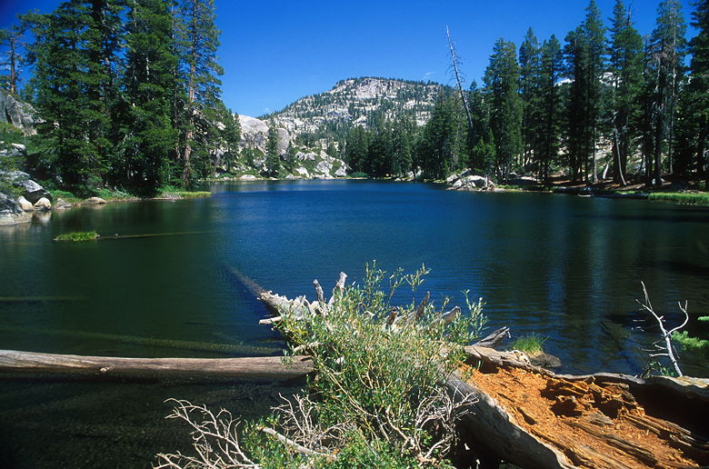
Camp Lake
After waiting for them to pass, we started down the steps. We passed one
straggler who appeared to be carrying two packs -- one on top of the other. He
must have been carrying over 80 pounds. Needless to say, he was going very
slowly up the steps. Soon after reaching the bottom of the steps, we reached
the aforementioned trail intersection. We took the right fork to continue on
toward Gem Lake.
The trail now emerges from the forest and begins a descent of 150-200 feet.
The trail switchbacks steeply (some of the switchbacks are about as small as the
table I'm using now) through low brush. Some parts of the trail are a bit narrow and in need
of maintenance. Pants would be good here, but I snaked through wearing my shorts
without hurting myself. Below and to the left, aspens are clearly visible.
At the bottom, we reached Lily Creek. A man was sitting at the base of a tree,
sipping a can of soda he claimed he'd stashed there weeks ago. There's a path
running along the creek to the right, but the man told us the real trail
continued across the creek. At this time of year, the creek was an inch or two
deep where we crossed, stepping on rocks the whole way.
The trail soon begins switchbacking up steep granite. We passed a couple
backpackers who were descending. We encountered very few hikers the rest of the
way between Camp Lake and Gem Lake. The trail climbs and climbs another 300 feet
before leveling off.
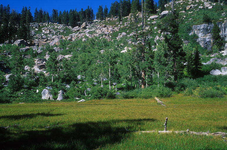
Aspen-backed meadow
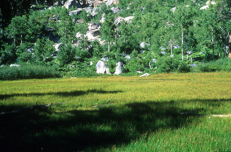
A closer look
I was beginning to worry about the time. Sunset was around 7:30pm, and we hadn't
reached Piute Meadow. From the map it looked like 3 miles separated Piute
Meadow from Gem Lake -- perhaps another 2 hours. So when we passed a small meadow
on the left, backed by aspen trees and a granite wall, I was hoping it was Piute
Meadow. If I studied the map more carefully, I would have known it wasn't.
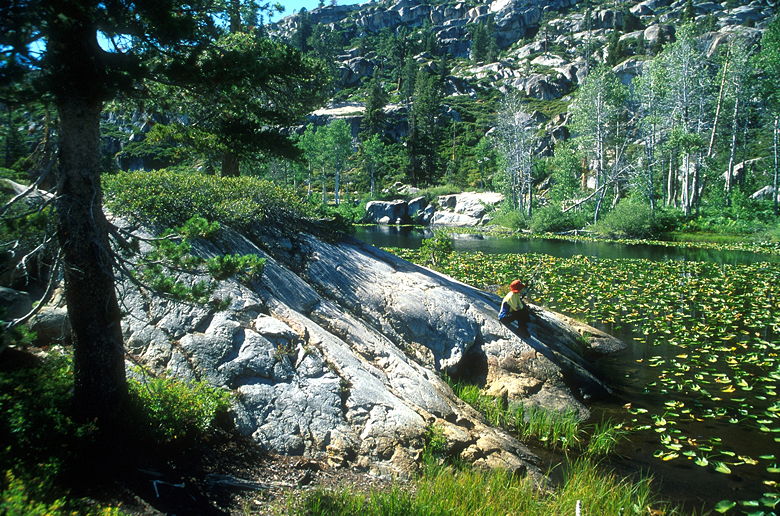
Jean checking out the lily pond
We then came upon a series of lily ponds. The ponds stretch far along the trail,
but aren't very wide. They're quite pretty, but there aren't many camping spots
nearby, as the trail now crosses a lot of bare granite marked by cairns. At
the far end of the ponds, we saw two women filtering water. I asked them if this
was Piute Meadow, but they said we still had a ways to go -- up a short ascent
in front of us, and then a long downhill. They said we should probably fill up on
water, but I said we had enough. I probably should have checked first, but I
was too lazy to take off my pack, and I just assumed since we packed so much that
we still had plenty.
Lily Pond
It was already 4:30pm, so we quickly made the ascent and the plunge down to Piute
Meadow. The meadow is visible from the trail, which descends about 350 feet. At
the bottom we crossed Piute Creek and came to the trail intersection for Groundhog
Meadow. A signpost marks the way in all directions. I'd worried about trail signs
before starting the hike, but I needn't have worried -- almost all the trails
on the map are signed (with one small exception I'll note later).
It was 5pm. I'd originally thought we could get into camp by 5:30 or 6pm, but now
it looked like 7pm at the earliest. Now that we stopped to rest, I took out my
pack and realized we didn't have enough water. I went over to the edge of the meadow
and found a small pond to filter water from. By the way, Piute Meadow will
probably be a disappointment for you if you have any expectations. On the map it
looks huge. But the trail
intersection is a big sandy spot with trees blocking any view of the meadow. I
suppose you can camp here, but it's definitely not the prettiest place in the
Emigrant Wilderness.
A couple of backpackers came from the opposite direction. We swapped descriptions of
the trail ahead. They were headed toward the lily pond. They said it had taken
them about an hour and a half to get here from Gem Lake; they said it would probably
take us 2 hours, since it'd be more uphill for us. They were doing a big loop
hike via Whitesides Meadow. From the map that looks like a nice 4 day/3 night trip.
It was nearly 5:40pm by the time we left the intersection. We climbed up about
250 feet, then downhill a bit before we reached Piute Lake. We would have stopped --
it looked pretty -- but we wanted to get to camp before sundown. The trail is now
flat for a long time and we zoomed through this section. The trail then begins
a relentless 380 foot climb up to Gem Lake. The sun had disappeared over the rim
of the mountains behind us, but we could see the sunlight still shining on the trees
above us. We climbed higher, chasing the sun until I could actually see our
shadows at one point. It was quite beautiful light on the trees, but we had no
time to stop and enjoy it.
We topped out around 7:30pm and found ourselves at Gem Lake, a gem if I ever saw one. The lake
sits in a small saddle with empty sky to the south and large granite walls
to the east. There were two or three other tents already set up as we started
the task of finding a good campsite. The one we really wanted was already taken,
so we eventually settled on one near the trail on the east side of the lake.
I doubt many people camp here
because it's sandy and rocky -- we had a hard time putting our stakes in.
In retrospect, we shouldn't have camped there, since it was less than 100 feet
from the water (I wasn't aware of the restriction at the time). However, we made
it a point to walk inland to brush our teeth and deposit our dish water. The
best campsites are probably the ones on the southwest side of the lake. But our
site did have some advantages. We set up our camp and started cooking.
In no time at all we were eating mashed potatoes, tuna, and tortillas.
Surprisingly, mosquitoes were not a problem for us. In fact, we left the rain
fly off since bugs, rain, and cold were not a concern. I rinsed myself off with
the lake water, and then watched as the stars came out. It was an amazing show.
There was no moon, so the stars held center stage. I could make out the big
dipper of course, but also so many other stars. I could clearly see the Milky Way --
I'm not actually sure if I've ever seen it with the naked eye before. I saw one,
two, three shooting stars. I saw the stars reflecting in the still waters of Gem
Lake. And, despite the fact that there was no moon -- no light source but the stars,
I could still see our tent and the granite rocks and make out shapes in the night.
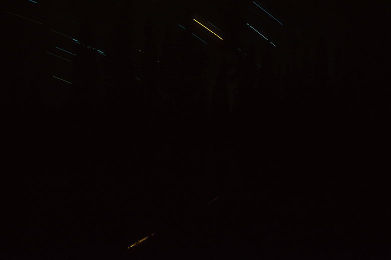
Stars reflecting in Gem Lake. Look closely and you can see the outlines of trees.
I regretted not bringing a star chart; even without one the stars were still impressive.
I took three 20 minute exposures with my camera. I hope at least one of them turns out.
We'll see...
| 

